
Landforms of Lowland Glaciation
by Devender
0 2627
Most of the glaciated lowlands have depositional features but where rock masses project above the level surface, they result in striking features of erosion.
Landforms of Lowland Glaciation
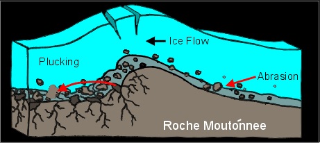
- Roche Moutonnee
- Plucking occurs on the leeward side due to a reduction in pressure of the glacier moving over the stoss slope
- So, it provides the opportunity for water to refreeze on the lee side and pluck the rock away
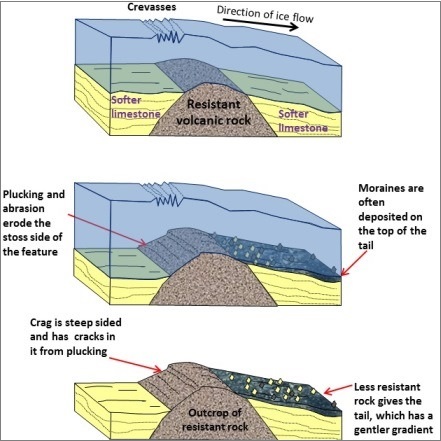
- Crag and Tail
- It has a gentle tail strewn with the eroded rock debris
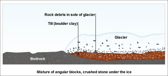
- Boulder clay or Glacial till
- Its fertility depends on the composition of the depositional materials
- Erratics
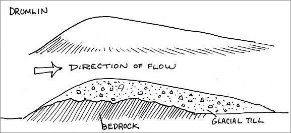
- Drumlins
- They are low hills up to 1.5 km long and 60 mm tall
- They appear steeper on the onset side and taper off at the leeward side
- They are arranged diagonally and commonly referred to as a basket of eggs topography
- Eskers
- The glacial tunnels mark the former sites of subglacial meltwater streams
- Their orientation is generally parallel to the direction of glacial flow
- They sometimes exceed 100 kilometers in length
- Outwash Plains
- Kettle lake
- Kames
It is basically a resistant residual rock hummock or mound, striated by the ice movement. Its upstream or stoss side is smoothened by abrasion and its downward or leeward side is roughened by plucking and is much steeper.
A crag and tail is a larger rock mass than a Roche moutonnee and same as a Roche moutonnee, it is formed from a section of rock that was more resistant than its surroundings.
The crag is a mass of hard rock with a steep slope on the upward side that protects the softer leeward slope from being completely worn down by the oncoming ice.
Boulder clay or Glacial till is an unsorted glacial deposit comprising a range of eroded materials such as boulders, sticky clays and fine rock flour. It is spread out in sheets, not mounds, and forms gently undulating till or drift plains with monotonous landform.
When ice melts, boulders of varying sizes are transported by ice and left stranded in the regions of deposition. It is called erratics because they are composed of materials entirely different from those of the regions in which they have been transported.
It is useful in tracing the source and direction of ice movements but their presence in large numbers causes hindrance in farming. These are also known as perched blocks as sometimes they are found perched in precarious positions as the ice dropped them.
Drumlins are elongated whale back-type hummocks composed wholly of boulder clay with elongation in the direction of ice flow that is on the downward side.
Eskers are the sinuous ridges composed of glacial material mainly sands and gravel deposited by meltwater currents in glacial tunnels.
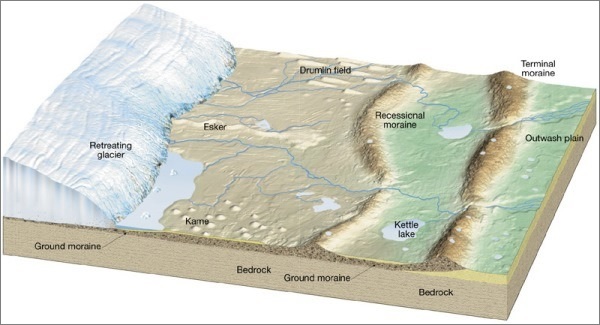
These are made up of fluvioglacial deposits washed out from the terminal moraines by the streams of stagnant ice mass. The meltwaters sort & redeposit the material mainly consisted of layers of sand and other fine sediments.
Such plains with their sandy soils are often used for specialized kinds of agriculture, such as the potato.
It is formed when the deposition takes place in the form of alternating ridges. Shallow, sediment-filled bodies of water formed by retreating glaciers.
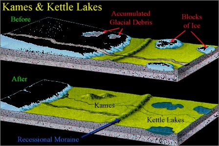
These are small rounded hillocks of sand and gravel which cover part of the plain. These are often associated with kettles, and this is referred to as kame & kettle topography.

Share:
You May Also Like

 – Tropical Grasslands")


Discount Coupons

Expand Your Business Reach


Comments
Waiting for your comments