
Landforms by Running Water
by Devender
0 4802
Denudation is the process of lowering the earth's surface by the agents of erosion such as Wind, Water, Ice, Waves, etc.
Landforms by Running Water
The glaciers & snow are confined to cold and temperate latitudes, the waves act only on coastlines, winds are only efficient in deserts but the effect of running water is felt all over the world, making it the most important agent of denudation.
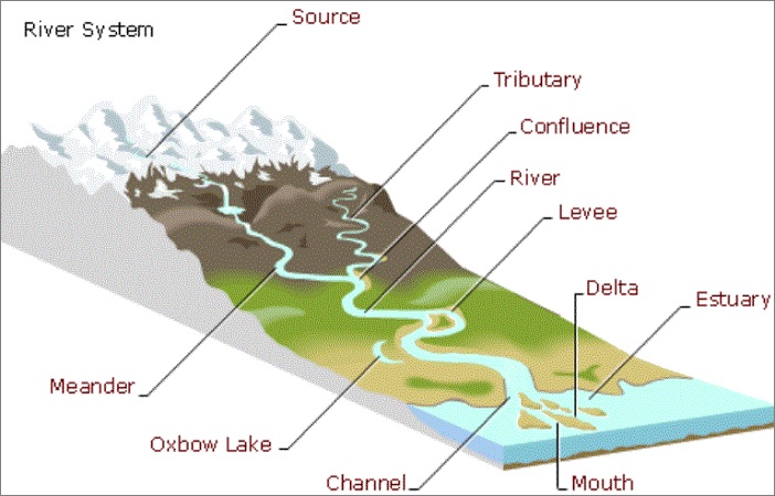
The source of the river is generally found in an upland region with a slope down for the run-offs. So, the uplands form the catchment areas of the rivers and the crest of mountains becomes the divide or watershed from which the streams flow down the slope.
- The initial stream that exists as a consequence of the slope is called the consequent stream
- The consequent stream is joined by several tributaries from either side as it wears down the surface
- The course of a River
- Gorge
- Rapids
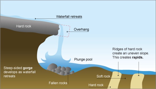
- Waterfall
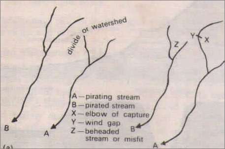
- River Capture
- Interlocking spurs
- River Cliffs
- Meanders
- Flood Plains
- Ox Bowl Lakes
- Deltas
- The predominant action of the river is vertical erosion
- The valleys developed are deep, narrow and distinctively V-shaped
- These valleys sometimes result in the formation of gorges and canyons
- River Capture
- Stream A may eventually break through the divide and capture and pirate stream B
- The bend at which the piracy occurs is termed as Elbow of the capture and the beheaded stream is called a misfit
- The valley below the elbow is a wind gap that may be useful for road and rail route
- Rapids, Cataracts and Waterfalls
- When river plunges down in a sudden fall from some height, they are called Waterfalls
- Their greater force usually wears out a plunge pool beneath
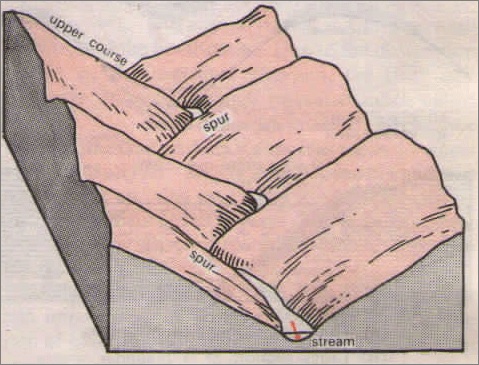
- Interlocking spurs
- River cliffs and Slip off slopes
- Meanders
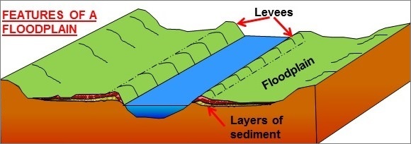
- Flood Plain
- Material is also deposited on the sides forming raised banks called Levees
- To minimize the risk of floods, artificial embankments are erected on the natural levees
- Ox-Bow Lakes (Dead Lake)
- Delta
- Active vertical & lateral erosion in the upper course of the river to provide extensive sediments
- The coast should be sheltered preferably tideless & no strong current at a right angle to the mouth of the river washing away the sediments
- Sea adjoining the delta should be shallow or else the load will disappear in deep waters
- No large lakes in the river course to filter off sediments
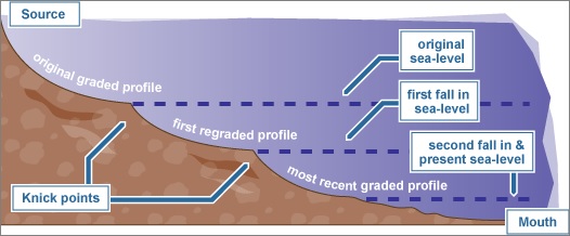
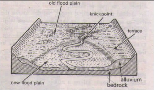
- This steepens the slope so that river's eroding power or downcutting is renewed
- River with its renewed vigor cuts into the former plain, leaving behind traces on both sides of the river
- Point where the old and rejuvenated profile meet is called Knick point, which can be seen as waterfalls and rapids
- If rejuvenation occurs in the upper course, the river valleys are deepened and steep-sided gorges are formed
- Entrenched meanders
- Ingrown meanders
- River terraces are particularly useful for settlements as they provide flat areas above the present floodplain
- Oxford, Cambridge, and London all are developed on the river terraces of the Isis, Cam, and Thames respectively
It can be divided into parts which are:
Upper Course
Middle Course
Lower Course
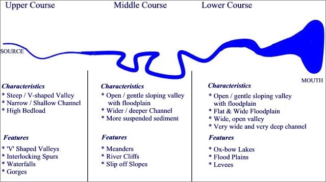
1Upper or Mountain Course (Youth stage)
It begins at the source of the river near the watershed, generally at the crest of the mountain range and its flow is very swift as it descends the steep slopes.
Some of the features associated with the upper course of the river -
It is also known as river piracy or river beheading. Its development depends upon the different rates of back cutting (headward erosion) into a divide mainly due to differences in precipitation received by streams.
If one side of the divide cuts more rapidly than the other then its greater erosive power will succeed in enlarging its basin at the expense of a weaker stream.
These are liable to occur in any part of river course but most numerous in mountains course where changes in gradient are more abrupt and frequent. The outcrop of hard rock may cause a river to jump and fall due to unequal resistance of hard & soft rocks transverse by a river.
2Middle or Valley Course (Maturity stage)
The lateral corrasion tends to replace vertical corrasion in the middle course, the active corrasion of the bank thus widens V-shaped valleys. The volume of the water also increases due to the confluence of many tributaries which increases the river's load.
The work of the river is predominantly transportation with some deposition in a clearer manner, although velocity does not decrease.
Some of the features associated with the Middle course of the river -
The interlocking spurs that project from both sides of the valley are cut back into a line of bluffs. The rainwash, soil creeps, landslides and gullying gradually widen the valley, cutting back the sides and as the stream flows on, the meanders migrate progressively outward with the interlocking spurs alternating with the undercut slopes.
Meanders in the middle course are only the beginning of the downward swing as bends are restricted by the interlocking spurs. In the lower course, the loops are enlarged across the level plain and meanders are fully developed.
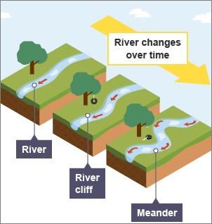
When the flow of water PQ enters the bend of the river, it dashes straight into Q, eroding the outer bank into a steep river cliff at Q.
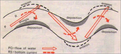
The water piles up on the outside of the bend due to centrifugal force. A bottom current RS is set up in a corkscrew motion and is hurled back into midstream and inner bank. Shingle is thus deposited here at S, where the slip-off is gentle. The outer bank is therefore the bank of continuous erosion & the inner bank is the bank of continuous deposition.
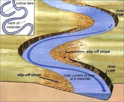
As water flowing under gravity seldom flows straight for long-distance, a winding course soon develops, the irregularities of the ground forces the river to swing in loops forming Meanders.
3Lower or Plain Course (Old Stage)
The river moving downstream across a broad, level plain is heavy with debris brought down from the upper course. The vertical corrasion has almost ceased through lateral corrasion still goes on to erode its banks further.
The volume of water is greatly swelled with work of the river is mainly depositional, building up its bed and forming flood plains.
Some of the features associated with the plain course of the river -
During sporadic floods, large quantities of sediments are spread over the low-lying adjacent areas by the rivers, thus gradually building up a fertile flood plain and when the river flows normally its bed is raised through the accumulation of deposits.
Nowadays, huge dredgers are also brought up in use to deepen the channels to avoid excessive sedimentation.
In the lower course, a meander becomes very common. The outside bank is so rapidly eroded that the river becomes almost a complete circle.
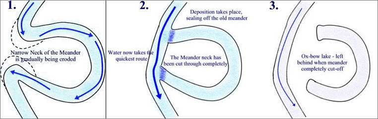
There comes a time, when the river cuts through the narrow neck of the loop, abandoning an Ox-bow lake and then flows straight. The ox-bow lake will later degenerate into a swamp through subsequent floods that may silt up the lake, thus becoming marshy and eventually dries up.
When the river reaches the sea, the fine materials it has not dropped yet are deposited at its mouth, forming a fan-shaped alluvial area called a delta. The alluvial tract is in fact the seaward extension of the flood plains. The river may discharge its water through several channels due to obstruction caused by the deposited alluvium called distributaries.
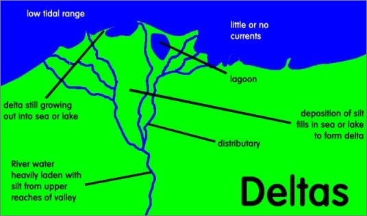
Favorable conditions for delta are –
River Rejuvenation
When in the course, if the river parts are uplifted or depressed, they rejuvenate the river and make it young again. It mainly occurs when there is either a fall in sea level relative to the level of the land or a rise of the land relative to the sea known as negative movements leading to falling in the river's base level.
The existing meanders are vertically eroded by the rejuvenated stream as the vertical corrasion replaces lateral corrasion in the middle and lower course. A distinct new trench is cut in the old valley and the river develops a deep valley with incised meanders that are of 2 types "entrenched meanders and ingrown meanders".
These are symmetrical and form when the river down cuts particularly quickly and due to the speed at which the river down cuts, there is little opportunity for lateral erosion to occur giving them a symmetrical shape.
These are asymmetrical and form when the river down cuts at a less rapid pace. It gives the river opportunity to erode laterally and vertically.
A rejuvenating river can erode vertically into the former flood plain to produce features called river terraces. If vertical erosion is rapid then paired terraces have formed either side of the channel. If vertical erosion is slower though, unpaired terraces form as the river is given the opportunity to meander.
A positive movement occurs when there is either a rise in sea level relative to the level of the land or a fall of the land relative to the sea level and this will submerge the land along the coast, drown the valleys and weaken the erosive power of the river.
The lower course of the river may be partly in the sea and features of deposition are shifted in the middle course with the upper course affected only a little. The rise in the sea level mainly occurs due to the release of the water locked up in the ice masses during the Quaternary ice ages.

Share:
You May Also Like


 – Tropical Grasslands")

Discount Coupons

Expand Your Business Reach


Comments
Waiting for your comments