
India Physiography – The Northern Mountains (Himalayas)
by Devender
0 10244
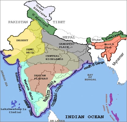
India can be divided into 6 physical divisions which are:
- The Northern Mountains
- The North Indian Plain
- The Peninsular Plateau
- Great Indian Desert
- The coastal Regions
- Islands
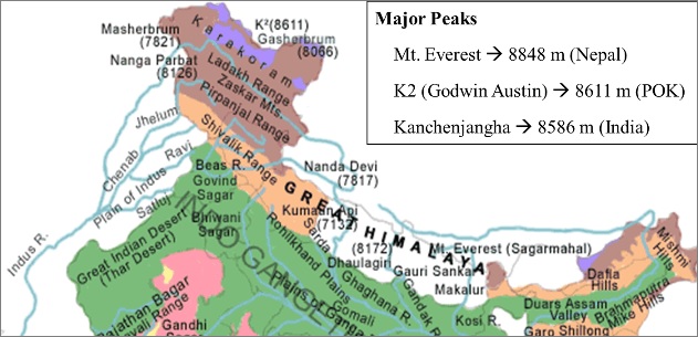
- These mountain ranges start from Pamir Knot in the west and go to Purvanchal in the east
- These mountain ranges are 2400 Km in length
- These are formed by Tectonic Forces
- The width of these ranges vary from 400 Km in Kashmir to 160 Km in Arunachal Pradesh
- Trans Himalayas
- Greater Himalaya (Inner Himalaya)
- Middle Himalaya
- Outer Himalaya (Shivalik Range/ Himachal)
- Ranges - Zaskar, K2 (Godwin Austin), Ladakh, Kailash and Karakoram Range
- It is mainly made up of granite
- Ranges - Mt. Everest, Kanchenjunga
- Forests type - Needle leaved coniferous
- Ranges - Pir Panjal, Dhaula Dhar, Mahabharat
- Forests type - Broad-leaved evergreen
- Example - Dehradun, Patlidun (longitudinal valleys)
- Forests type - Deciduous type forests
- Eastern hills/Purvanchal
- Mishmi Hills, Patkai Hills, Naga Hills, Manipuri Hills, and Mizo Hills
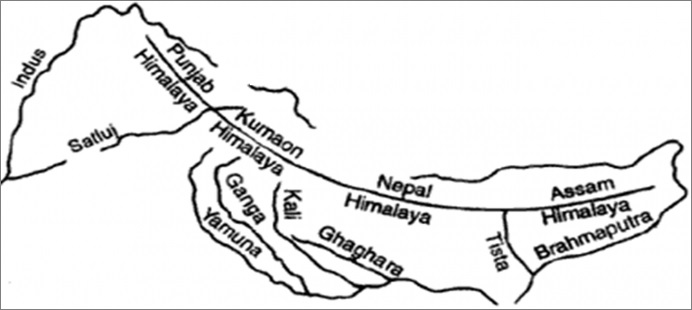
- Punjab Himalayas/Kashmir Himalaya/Himachal Himalaya - Between the Indus and Sutlej
- Kumaon Himalayas - Between Sutlej and Kali rivers
- Nepal Himalayas - Between Kali and Tista rivers
- Assam Himalayas - Between Tista and Dihang rivers
- It acts as a natural frontier of India with other countries such as China, Pakistan, etc.
- It prevents northward movement of the summer monsoon and also prevents cold northern winds from Siberia to enter India
- The rivers from the Himalayas deposit a lot of sediment on their foothold forming the most fertile agricultural grounds known as the Northern plains of India
- The Himalayas provide India with huge hydro-electric power, timber, Herbs & Medicinal plants
- The Himalayas have large ecological biodiversity, natural views & hill stations
The Northern Mountains (Himalayas)
The northern mountain region of India is formed by the Himalayan Mountains which are the highest mountain ranges in the world. These are also the Youngest & Loftiest mountain range in the world.
The altitude variation is more in the eastern part as compared to western parts and its prominent features are - Highest peaks, Deep valleys & Gorges, Glaciers, etc.
The Himalayan Mountains can be further divided into the following ranges:
1 Trans Himalayas
These are to the immediate north of the Great Himalayan range and known as Tibetan Himalaya as most of the part of this range lies in Tibet.
2 Greater Himalaya (Inner Himalaya)
This range is always covered in snow and is known as Himadri. The average height of it is 6000 mts and it is known as the most continuous range.
3 Middle Himalaya
This range has an average height of 3500 to 4500 mts and most of the valleys and hill stations are found in this range such as Kashmir, Kathmandu, Nainital.
4 Outer Himalaya (Shivalik Range/ Himachal)
This range has an average height of 600 to 1200 mts and most of the Dun & Duars are found in this range.
The eastern boundary of the Himalayas is marked by the Brahmaputra. After the Dihang gorge, the Himalayas turns sharply towards the south forming the Eastern hills or Purvanchal. These run through NE India & are mostly composed of sandstones.
Classification of Himalayas on the basis of Geographic Location:
Significance of the Himalayas for India:

Share:
You May Also Like


Discount Coupons

Expand Your Business Reach


Comments
Waiting for your comments