
Indian Drainage system Features & Patterns
by Devender
0 2622
Indian Drainage system Features & Patterns
- Himalayan Drainage vs Peninsular Drainage
- The perennial flowing rivers are fed with rain and melting glaciers
- The rivers are geologically young with a long course of flow
- These rivers flow through lose alluvial soils of northern plains
- Due to intensive erosion, they form deep valleys and gorges
- These rivers have deeper basins and large catchment areas
- These rivers are geologically older and have a shorter course of flow
- These rivers flow through hard granitic soils of peninsular India
- Due to little erosion, these rivers form shallow graded valleys
- These rivers form small waterfalls, deltas, and estuaries
- West Flowing Rivers vs East Flowing Rivers of Peninsular India
- These rivers are geologically young
- They generally form estuaries and not deltas
- The valley floors of these rivers are much above the sea level
- These rivers flow swiftly into the sea
- These rivers are geologically old
- These rivers have large catchment areas and form deltas
- These rivers flow sluggishly into the sea
- Their valley floors are at sea level
- Drainage basin
- Watershed Divide
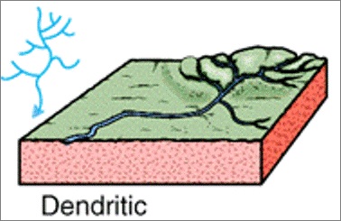
- The river channel follows the slope of the terrain
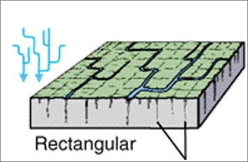
- Erosion is resisted by homogeneous beds
- The streams run in all directions without particular favorable to any particular region
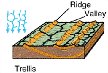
- These are the regions that went under faulting
- It has a uniform resistance to erosion
- The streams meet at approx. right angle
- It develops on strongly joined rocky terrain
- The river is joined by tributaries at approx. right angle
- It develops in folded topography which is alternate layers of hard & soft rocks
- The longer streams have a preference to one direction
- Tributaries prefer the right angle to the mainstream
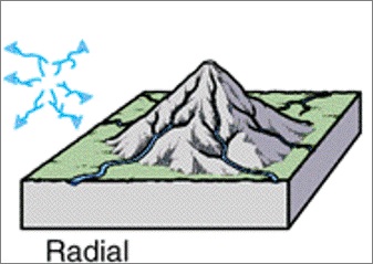
- The streams flow in different directions from the central peak
- Outflowing rivers, away from a central point, analogous with the spokes of a wheel
- Generally, the rivers flowing through dome Mountains and volcanoes
1 Himalayan Drainage:
It is an Antecedent kind of drainage as the Himalayan rivers are older than the lesser Himalayas and Shiwaliks. The rivers cut across structures that are younger than them.
The Himalayan rivers generate large quantities of sediment and cause annual floods. These rivers also form deltas and the nature of the river is changing, meandering, forming ox-bow lakes & high waterfalls.
2 Peninsular Drainage:
It is of Super-imposed drainage type as the structures are older than the rivers. The nature of the flow of these rivers is seasonal, it is major during the southwest monsoon.
1 West Flowing Rivers:
These rivers flow in the Arabian sea through rift valleys in the straight linear courses. These rivers do not have an extensive network of tributaries.
2 East Flowing Rivers:
These rivers flow into the Bay of Bengal and have an extensive network of tributaries.
Watershed
It is that geographic area through which water flows across the land and drains into a common body of water which could be a stream, river, lake, or ocean. The watershed boundary will follow the highest ridgeline around the stream channels and meet at the bottom or lowest point of the land, the mouth of the waterway where water flows out of the watershed.
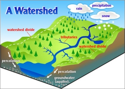
It is an area of land where surface water from rain, melting snow, or ice converges to a single point at a low elevation. It is also known as a catchment basin.
It usually converses at the exit of the basin where the water joins another body such as a river, lake, reservoir, estuary, wetland, or sea. So, it can also be called an area drained by tributary streams that come together into the main channel.
It is the line that divides the surface runoff between two adjacent river basins. It is also known as the topographic water divide.
It marks the highest points between the basins, but isolated peaks within a basin may reach higher elevations than any point on the divide.
Stream or Flowing River Patterns
The consolidated impacts of environment and geography on the catchment geology yield a disintegration design, which is portrayed by an organization of streams. Some of the most seen stream patterns are:
1 Dendritic River Pattern
For Example - Indo–Gangetic Plains
2 Rectangular River Pattern
For Example - the Vindhya Mountains of India
3 Trellis River Pattern
For Example- the Appalachian Mountains of North America & Singhbhum (Chotanagpur Plateau)
4 Radial River Pattern
For Example - Rivers Narmada, Son, and Mahanadi originating from Amarkantak Hills; Girnar Hills (Kathiawar, Gujarat), and Mikir Hills of Assam
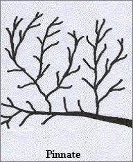
5 Pinnate River Pattern
In this pattern, the mainstream runs in one direction while the tributaries join it at an oblique angle.
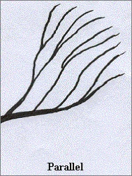
6 Parallel River Pattern
In this pattern, the mainstream runs in one direction and the tributaries also join it running in the same direction.

Share:
You May Also Like


Discount Coupons

Expand Your Business Reach


Comments
Waiting for your comments