
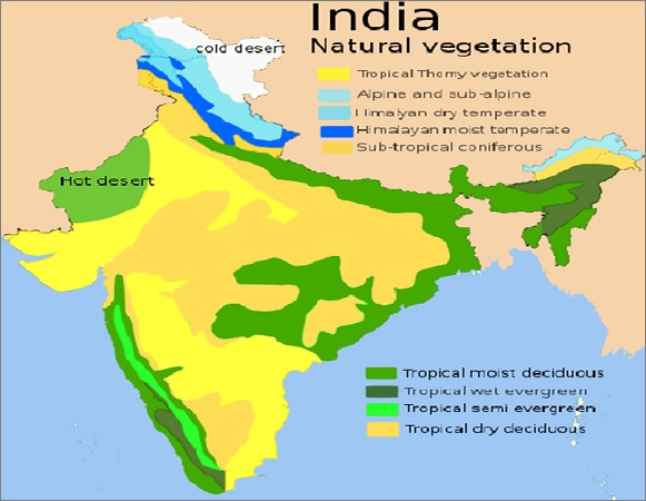
Natural Vegetation of India
by Devender
0 2788
The Natural Vegetation of India can be divided into these 6 groups which are:
- Tropical Evergreen Rain Forests
- Deciduous or Monsoon Type of Forests
- Tropical dry Deciduous Forests
- Arid Forests and Desert Vegetation
- Tidal or Mangrove Forests
- Mountain Forests
- These are hardwood forests
- Sunrays are not able to reach the earth surface
- The trees in these forests compete with each other to grow taller to get sunlight
- These forests are found at WGs, A & N islands and Eastern India
- The trees shed their leaves in summer due to a shortage of water
- These are very important forests economically
- These forests are found at Shiwaliks, Ganga valley, WGs, NE India
- The roots of trees are long and thick to use the underground water
- The bark of the trees are also thick to prevent an unwanted evaporation
- Most areas of such forests are used for agriculture
- Dwarf Deciduous trees and long- grasses grow in these regions
- Indian wild date is very common in these forests
- These forests are found in Western Rajasthan, SW Haryana & Punjab, and in some parts of Gujrat
- These forests consist of thick Bushes & Ferns
- These are known as Halophytes as they are tolerant of salinity
- On the foothills of the Himalayas, up to a height of 1500 meters, evergreen trees, (Sal, teak, bamboo, and cane) grow abundantly
- On a higher slope between 1,500 meters to 3,500 meters, temperate conifer trees (pine, fir, oak, maple, deodar, laurel spruce, cedar) grow
- At the higher altitude of the Himalayas, rhododendrons and junipers are found
- Overgrazing
- Forest Fire
- Reckless Cutting of Trees
- Jhum Cultivation
- Reserve & Protected forests
- Van Mahotsav Program
- Forest Research Institute at Dehradun
- National Forest policy
- Social Forestry
- It also helps in generating employment
- It also helps in generating additional income
- Forest Protection by Government officials
- Around 54 % of the total forest area comes under it
- It has a full degree of protection
- These forests are also looked after by the government
- These have very limited protection
- Around 29 % of the total forest area comes under this category
- National Park
- Human interference is totally prohibited
- Villagers cannot graze their animals
- Extremely strict rules about jungle produce (a collection for ex. Honey)
- Wildlife Sanctuary
- Human activities are allowed like Grazing of animals, Firewood collection, Tourism
- A sanctuary can be upgraded to a National park but not vice versa
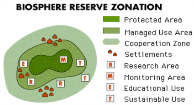
- Biosphere Reserve
- Core zone - Central area that has to be kept undisturbed of all activities except research (which don’t disturb wildlife)
- Buffer zone - Some light activities like tourism, fishing, grazing, etc. are allowed which don't disturb the core zone. Research activities are encouraged here
- Transition zone - Outmost part and not delimited but activities have to be harmonious with the biosphere reserve
- Conservation Reserves
- Such announcements can only be made after having consultations with the local communities
- Community Reserves
- Mainly where an individual or a community has volunteered to conserve wildlife and its habitat
Natural Vegetation of India
1 Tropical Evergreen Rain Forests
These forests have an average rainfall of Above 200 cm and with a temperature above 24 Degree Celsius. These forests are found in Hot & Humid areas of India. These forests are tall and dense with a height of around 45 to 60 m.
For Example - Rubber, Coconut, Ebony, Mahogany, Palms
2 Deciduous Forests
These forests have an average rainfall of 100 to 200 cm and an average height of 25 to 45 m.
For Example - Sal, Teak, Shisham, Sandalwood, Deodar, Mahua
3 Tropical dry Forests
These forests have an average rainfall of 50 to 100 cm and an average height of 6 to 9 m. These forests are less dense and small in size.
These forests are often found in Punjab, Haryana, MP, Eastern Rajasthan, Central Deccan Plateau. For Example - Neem, Shisham, Babul, Pipal, Mango
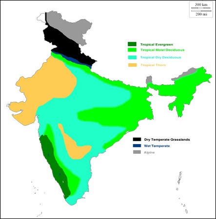
4 Arid or Desert Forests
These forests have an average rainfall of less than 50 cm. The trees of these forests have Small leaves, Thick Bark, and Long Roots.
For Example - Small-sized kikar, Babul, Acacia, Bushes and Shrubs
5 Tidal Forests
These forests grow along the coast and on the edges of the deltas and are famous for Mangrove and Sundari Trees.
These forests are mainly found at Sundarbans, A & N Islands, Deltas of Mahanadi, Godavari, Krishna & Kavery
6 Mountain Forests
These forests grow variably along the slopes of mountains.
Alpine grasslands appear up to snowfield beyond these vegetation belts.
Forest Cover of India
Until 2015, 34 % of the total geographical area of India came under forest cover. The total forested area in India is about 63.73 million hectares.
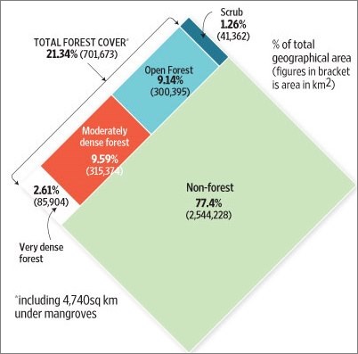
In the last 10 years, the forest cover of the country has increased by 3.31 million hectares i.e. an average 0.46% increase every year. The problem associated with Forestry are:
Government Initiatives
Thousands of trees are planted every year in the months of July and August with this program.
For the promotion and preservation of the forests properly.
National Forest Policy, 1988:
It was for the conservation of Biodiversity, Afforestation and Check of soil erosion. According to it, 33 % of Geographical area shall be covered with forest and development of Social Forestry such as Agro-Forestry, Community Forestry and Forestry by officials.
It is mainly to reduce the pressure on traditional forests by planting trees for fuelwood, Timber and other social supplies. It also helps in checking water and wind erosion by acting as shelterbelts.
Reserved Forests
These forests are under the direct supervision of the government. The area is notified under the provisions of FRA and no public entry is allowed for the collection of timber or grazing.
All activities in this area are prohibited unless it is prohibited by officials.
Protected Forests
These forests have area notified under the provisions of FRA and all activities here are permitted unless prohibited.
Local people are allowed to collect fuelwood, timber and to graze their animals without causing serious damage to the forests.
Unprotected Forests
These forests have no restriction on cutting trees or cattle grazing. Around 18 % of the total forest area comes under this category.
Forest & Wildlife Protection Programmes by Government
These are large areas consisting of one or more ecosystems and operated at the National Level. No human activity or settlement is allowed in these areas.
These areas are created for a particular species which is not the case with the national parks and are operated at State Level.
The unique ecosystem of terrestrial & coastal areas is internationally recognized by UNESCO under the Man and Biosphere (MAB) program. People are allowed to live, own private land & carry own traditional activities but only in the outer zone.
Any area can be declared as a Conservation Reserves by the State Governments and particularly the areas adjacent to National Parks and Sanctuaries and those areas which link one Protected Area with another.
Any private or community land can be declared as Community Reserve by the state government not comprised within a National Park, Sanctuary, or a Conservation Reserve.

Share:
You May Also Like


Discount Coupons

Expand Your Business Reach


Comments
Waiting for your comments