
India Physiography – The Indian Peninsular Plateaus
by Devender
0 4130
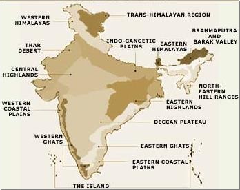
India can be divided into 6 physical divisions which are:
- The Northern Mountains
- The North Indian Plain
- The Peninsular Plateau
- Great Indian Desert
- The coastal Regions
- Islands
- These are triangular in shape
- Are composed of the oldest rocks
- Are surrounded by hills
- Narmada - Tapi divides into two parts
- The Central Highland
- The Deccan Plateau
- Malwa Plateau
- Bundelkhand Plateau
- Chhotanagpur Plateau
- It is volcanic in nature
- It is made up of horizontal layers of solidified lava forming trap structure with a step-like appearance
- The average elevation of Western Ghats is 900 to 1600 meters
- The average elevation of Eastern Ghats is 600 meters
- It has slopes towards east and south
- It descends abruptly towards the west making Sahyadri ranges
- Western Ghats:
- These are separated from the coast by narrow coastal plains
- The rich watersheds of Western Ghats give birth to large peninsular rivers such as Godavari and Krishna
- It extends from Tapi in North to Kanyakumari in south
- Thalghat ~ Mumbai ~ Kolkata
- Bhorghat ~ Mumbai ~ Chennai
- Palghat ~ Kochi ~ Chennai
- Nilgiri range with the highest peak Doda Betta along Ooty (Udhagmandalam) TN
- Anaimudi is the highest peak of South India
- Eastern Ghats:
- It doesn't give birth to any important rivers like the Western Ghats
- These are separated from the coast by very wide coastal plains
- The Eastern Ghats are geologically older than the Western Ghats
- Telangana Plateau:
- Karnataka Plateau:
- Dandakaranya Plateau:
- Shillong Plateau:
The Peninsular Plateaus
These are the largest of India's physical divisions. It mainly comprises broad and shallow valleys with rounded hills.
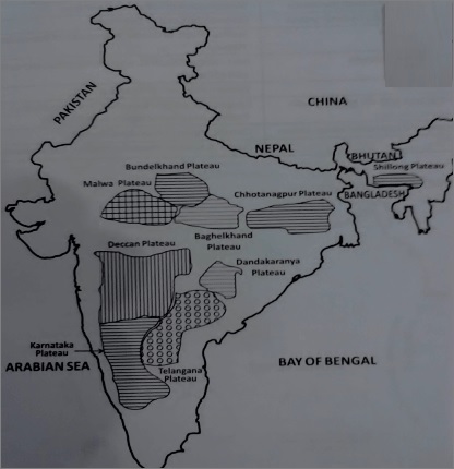
The Peninsular Plateau can be further divided into the following:
1 The Central Highlands
These lands lie north of the Narmada river and between the Aravali and the Vindhya range covering a major portion of the Malwa plateau (Madhya Pardesh).
The rivers flowing here indicates the slope of the region which flows southwest to northeast. The further extension of it are Bundelkhand, Bhaghelkhand & Chhota Nagpur Plateau.
Chambal and Betwa flow through this region forming a region not fit for cultivation and known as Badland.
It lies in Madhya Pradesh between Aravali and Vindhya ranges. Its extensions are Bundelkhand, Bhaghelkhand & Chota Nagpur Plateau.
It lies along the border of UP & MP and it has been transformed into ravines by extensive erosional activities of river Chambal & its tributaries.
It is the NorthEastern part of the Peninsular plateau that includes Jharkhand, parts of Chhattisgarh & WB.
Its highest peak is Parasnath. This Plateau is famous as the Patland plateau & known as the Ruhr of India.
2 Deccan Plateau
It is the largest plateau in India and it lies south of the Narmada river. It is shaped like an inverted triangle and surrounded by Satpura hills, Mahadeo hills, Maikala range, Amarkantak hills and Rajmahal hills in the north, the Western Ghats in the west, and the Eastern Ghats in the east.
The solidified lava is inter-trapping in structure because of the presence of the sedimentary layers in between layers of solidified lava. This plateau is very suitable for the cultivation of cotton. It is also a rich mineral source, a source to generate hydroelectric power.
The Western Ghats are the folded parts of the Deccan Plateau and are also known as Shayadries. These are continuous and higher as compared to the Eastern Ghats.
Important Passes (Rail Links):
Important Hill Ranges:
The Eastern Ghats extend from Odisha to the North of Nilgiri hills and are discontinuous & lower than the Western Ghats.
Mahanadi, Godavari, Krishna, Kaveri go through this range to get to the Bay of Bengal. The Eastern Ghats meet with the Western Ghats in the Nilgiri hills.
It is also a part of the Deccan Plateau and is located on the north of river Krishna.
It is situated south of the Deccan lava region. It consists of Bababudan hills and it is famous for iron ores.
It forms parts of Chhatisgarh & Odisha and contains igneous & metamorphic rocks of the Archaean period. The river Indravati & Mahanadi flows through this plateau and it is mainly inhabited by Gond tribes.
It is a part of the Peninsular Deccan Plateau and is made up of Garo, Khasi & Jaintia Hills. Mawsynram (World’s highest rainfall receiving point) is situated here.

Share:
You May Also Like


Discount Coupons

Expand Your Business Reach


Comments
Waiting for your comments