
Physiographic Divisions of India
by Devender
0 3513
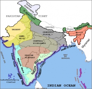
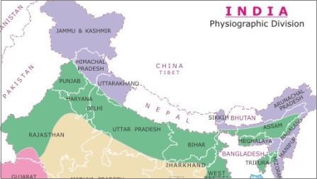
India can be divided into 6 physical divisions which are:
- The Northern Mountains
- The North Indian Plain
- The Peninsular Plateau
- Great Indian Desert
- The coastal Regions
- Islands
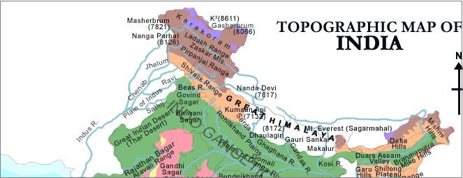
- They are formed by the tectonic collision of the Indian plateau with the Eurasian plateau
- These are the loftiest and one of the most rugged mountain barriers of the world
- They form an arc and cover a distance of 2400 km in length
- The width of these mountains is varying from 400 km in Kashmir to 160 km in Arunachal Pradesh
- The Trans Himalayas:
- Zaskar
- K2 (Godwin Austin)
- The Ladakh
- The Kailash
- The Karakoram
- Greater or Inner Himalayas/Himadri:
- Mt. Everest
- Kamet
- Kanchenjunga
- Nanga Parbat
- Annapurna
- The lesser Himalaya or Himachal:
- Dhaula Dhar and the Mahabharat ranges are also prominent ranges
- The famous valley of Kashmir, the Kangra, and Kullu Valley of Himachal Pradesh lies in this system
- The majority of Hill stations of India lie in this range
- The Shiwaliks:
- Eastern Hills and Mountains:
- Himalayan Ranges from East to West:
- Karakoram
- Ladakh
- Pir Panjal
- Zaskar
- Dhaola Dhar
- These Himalayas contains the sources of sacred rivers such as the Ganga and the Yamuna
- Some important lakes are Nainital and Bhimtal
- A famous valley of this region is Kathmandu
- Mt. Everest, Kanchenjunga, Lhotse I, Makalu, Dhaula Giri, and Annapurana are some important peaks of the region
- Namcha Barwa, Kula Kangri, and Chomo Lhari are some important peaks of this region
- It is about 2400 km long
- It is about 240 to 320 km broad
- Punjab Plains: It is formed by the Indus and its tributaries. A major part of this plain lies in Pakistan and it forms the western part of the northern plain.
- Ganga Plains: The Ganga plains consist of the northern states, Haryana, Delhi, UP, Bihar, part of Jharkhand, and West Bengal. It extends between the Ghaggar and Tista rivers.
- Brahmaputra Plains: It lies in Assam and forms the eastern part of the northern plain.
- Bhabar: The Rivers deposit pebbles in a narrow belt after descending from the mountains. The width of this belt is about 8 to 16 km and it lies parallel to the Shiwaliks. All the streams disappear in this region.
- Terai: It lies south of the bhabar belt and the streams reappear in this region. It is a wet, swampy, and marshy region.
- Bhangar: It is the largest part of the northern plain and consists of the oldest alluvial soil. It lies above the flood plains and resembles terraces. The soil of this region is composed of calcareous deposits and is known as kankar.
- Khadar: The floodplains formed by the younger alluvium are called khaddar and the soil in this region is renewed every year making it highly fertile.
- The Central Highlands:
- It is wider in the west and narrower in the east
- The eastward extension of this plateau is marked by Bundelkhand and Baghelkhand
- It further extends towards the east into the Chhotanagpur plateau
- The Deccan Plateau:
- Located between the Eastern Ghats and the Western Ghats
- The average elevation of Western Ghats is 900 to 1600 meters
- The average elevation of the Eastern Ghats is 600 meters
- It is home to the thick dark soil which is suitable for cotton cultivation
- Luni is the only prominent river in this region
- However, some streams do appear during the rainy season
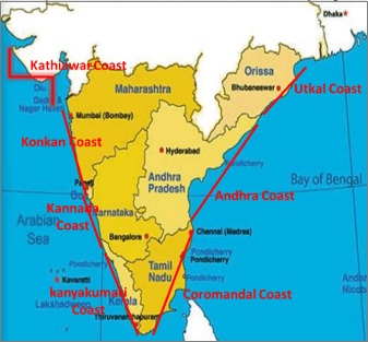
- Western Coastal plains:
- It lies between the west coast of India and the Western Ghats hills
- The plains begin at Gujarat in the north and end at Kerala in the south
- It includes the states of Maharashtra, Goa, and Karnataka
- The Gulf of Kutch and the Gulf of Khambat lies in the northern part
- Kathiawar Coast - Kutch to Daman (Tapti, Narmada, Sabarmati & Mahi river deposit a huge load of sediments in the Gulf of Cambay & form estuaries)
- Konkan Coast - Between Daman & Goa
- Kannada Coast - Between Goa to Cannanore
- Kanyakumari Coast - Between Cannanore to Cape Camorin
- Malabar coast, Kannada Coast, and Kanyakumari Coast
- Eastern Coastal Plains:
- It stretches from Tamil Nadu in the south to West Bengal in the North
- Utkal coast - Deltaic plains of Ganga to Mahanadi delta (Famous Chilka lake is located in this plain)
- Andhra Coast - Utkal plains to Pulicat lake (Contains deltas of Godavari & Krishna Rivers, & famous Kolleru lake)
- Northern Circars - Utkal Coast + Andhra Coast (Between Mahanadi & Krishna)
- Coromandal Coast - Between Krishna & Kanyakumari (Consist of Kaveri Delta)
- The Andaman and Nicobar Islands in the Bay of Bengal consists of hard volcanic rocks
- They are also the largest islands of India
- Lakshadweep islands in the Arabian Sea are formed by the corals
Physiographic Divisions of India
1 The Northern Mountains/ Himalayan Mountains:
These are young and structurally fold mountains. They stretch over the northern border of India. They run in a west-east direction from the Indus to the Brahmaputra.
The variations in altitude are greater in the eastern part than the western.
The Trans Himalayas are the ranges that lie immediately to the north of The Great Himalayan Range. Most of the parts of this Himalayan range lie in Tibet and hence, it is also known as Tibetan Himalaya.
The main ranges of the Trans Himalayan system are:
These are the most continuous range. It consists of the loftiest peaks with an average height of 6000 meters containing all the prominent Himalayan peaks. The core of this part of the Himalayas is composed of Granite.
They are permanently snowed bound and a number of glaciers descend from this range. The prominent ranges of this system are:
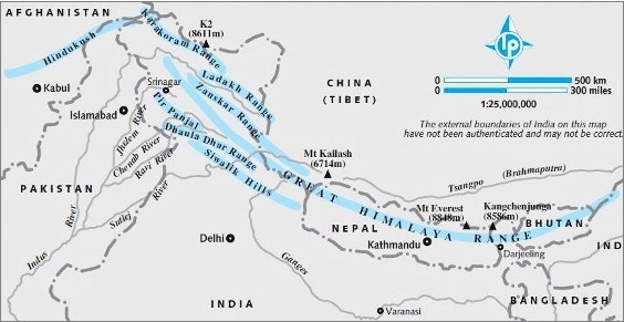
The altitude of these ranges varies between 3700 to 4500 meters. The average width is around 50 Km. The Pir Panjal range forms the longest and the most important range of this system.
Their altitude varies from 900 to 1100 km while the width varies from 10 to 50 km. The longitudinal valleys lying between the Himachal and the Shivalik are known as Dun. For example – Dehradun, Kotli Dun, and Patli Dun
The eastern border of the Himalayas is marked by the Brahmaputra. The Himalayas bend sharply towards the south forming the Eastern hills or Purvanchal. These hills run through the northeastern states of India.
These hills are mostly composed of sandstones. For example - Patkai Hills, Naga Hills, Manipuri Hills, and Mizo Hills.
Punjab Himalayas
It lies between the Sutlej and the Indus. It is 560 km long and is also known as Kashmir Himalayas and Himachal Himalayas. The major ranges of this section are:
Kumaon Himalayas
It lies between Sutlej and Kali rivers. It is 320 km long and its western part is known as Garhwal Himalaya while the eastern part is known as Kumaon Himalaya. Its elevation is higher than the Punjab Himalayas.
It important peaks are: Nanda Devi, Kamet, Trisul, Badrinath, Kedamath, and Gangotri
Nepal Himalayas
It lies between the Kali and Tista rivers. It is 800 km long and crowned with some perpetual snow peaks. It is the tallest section of the Himalayas.
Assam Himalayas
It lies between the Tista and Dihang rivers. It is 750 km long and its elevations are much lower than the Nepal Himalayas. The northern slopes are very gentle whereas the southern slopes are very steep.
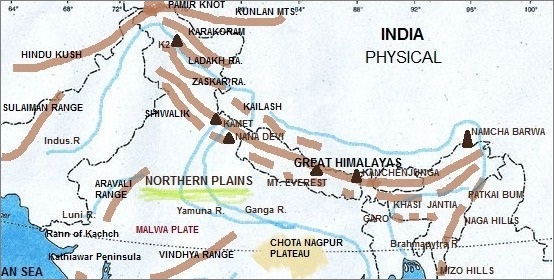
2 The Northern Plains:
It is formed by the interplay of three major river systems that are: the Indus, the Ganga, and the Brahmaputra along with their tributaries. It is composed of alluvial soil that has been deposited over millions of years.
It is an agriculturally very productive part of India because of the rich soil cover, adequate water supply, and favorable climatic conditions. It is divided into 3 sections namely: the Punjab plain, the Ganga plain, and the Brahmaputra plain.
The northern plain can be divided into 4 regions based on the relief features. These regions are: Bhabar, terai, bhangar, and khaddar.
3 The Peninsular Plateau:
The peninsular plateau is triangular in shape and surrounded by hills. It is composed of the oldest rocks as it was formed by the drifted part of the Gondwana land. The characteristics features of this plateau are broad, shallow valleys and rounded hills.
The plateau can be further divided into two regions: the Central Highlands and the Deccan plateau.
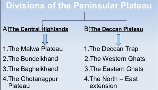
The central highlands cover a major portion of the Malwa plateau and lie to the north of the Narmada River. The flow of the rivers in this region is from southwest to northeast indicating the slope of the region.
It is the largest plateau in India and makes most of the southern part of India. It is shaped like a downward pointing triangle and lies to the south of the Narmada river.
Both these rise from their respective nearby coastal plain and almost meet at the southern tip of India. Its northern boundary is formed by the Satpura and Vindhya ranges that separate it from the Gangetic plain to the north.
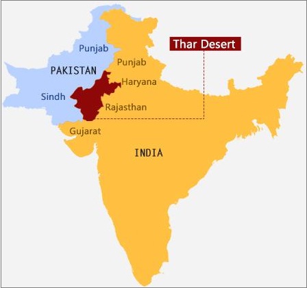
4 The Indian Desert:
The Indian desert lies towards the western margins of the Aravali hills. This region gets very limited rainfall which is less than 150 mm in a year. Therefore, the climate of the region is very arid and there is a scanty of vegetation.
5 The Coastal Plains:
The stretch of narrow coastal strips flanks the peninsular plateau and runs along the Arabian Sea on the west and the Bay of Bengal on the east.
It is a thin strip of coastal plain and of 50 km in width which is much less compared to the eastern coastal plains.
The western coastal plain can be divided into the following sections:
It refers to a wide stretch of the landmass of India. It lies between the Eastern Ghats and the Bay of Bengal. The plains are wider and level as compared to the western coastal plains.
It can be divided into the following sections:
6 The Islands:
India has a total of 247 islands out of which 204 lie in the Bay of Bengal while 43 are in the Arabian Sea. However, there are also a few coral islands in the Gulf of Mannar.
The southernmost point of India is in Nicobar Island and known as Indira point. It was formerly known as Pygmalion point but it submerged after the 2004 Tsunami.

Share:
You May Also Like


Discount Coupons

Expand Your Business Reach


Comments
Waiting for your comments